
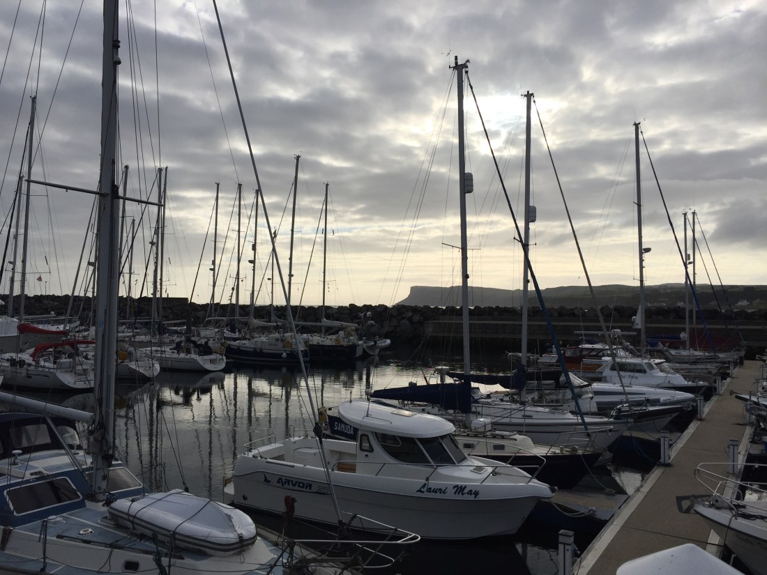
We up here in the north, woke to a greyish sort of day…. but dry and on the downside, no wind. Again the forecasts had predicted Force 3 to 4 winds…. but none evident. Then a visit to the Ballycastle showers…. a brand new block housing the Marina office, the Harbour Master and Tourist Information…. all modern and shiny clean. The toilets and showers are to be commended.
A secondary purpose to our visit to Ballycastle, in County Antrim in the far north of Ulster…. was that as a very young boy in the 1950’s…. for a short period of time I attended the Ballycastle Primary School as a pupil. We lived in one of the Coastguard Cottages up the hill for about a year before returning to Kenya, East Africa. I recall three things about Ballacastle… even after 60 years… the school, the stone jetty at the harbour and the walk home up a steep hill to the Coastguard Cottages. So I managed to go and locate the school… and there it was not far from the town centre and sea front…. 500 yards from the marina where we were berthed.

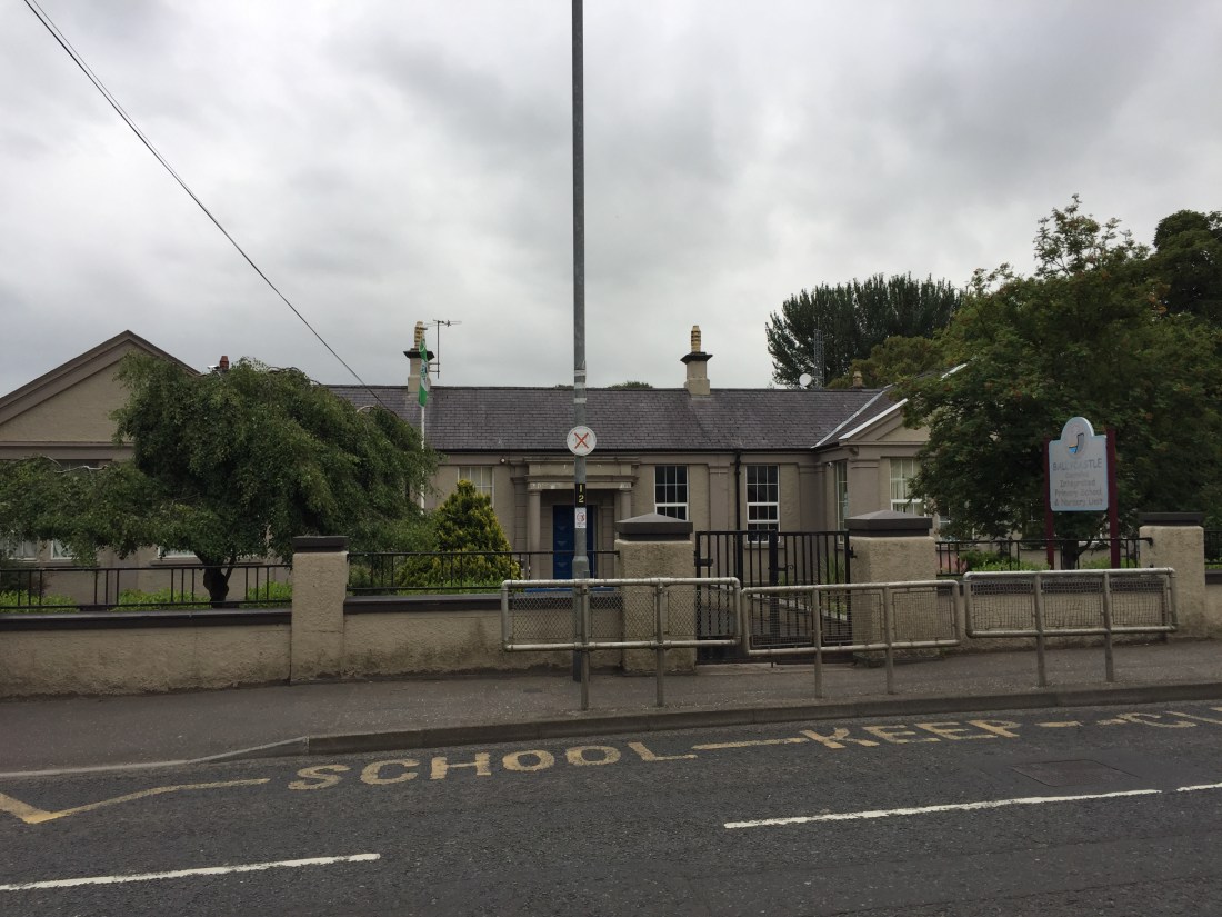
Photos of Ballycastle Primary School…. the two gable ends are the give away… and I remember the pale grey sort of rendering which doesn’t seem to have changed.
Ballycastle is a small town in County Antrim, located on the north-easternmost coastal tip of the island of Ireland. The town’s seafront overlooks a huge sweeping arc of a beach… which on the eastern head stands the quite fearsome headland… inappropriately named Fair Head. In 2016, the Sunday Times named Ballycastle as the best place to live in Northern Ireland. It had a good feel to it…. and some amazing views too, including Rathlin Island to the north… and on a clear day I can imagine you being able to see the islands of Islay, Jura, and the Mull of Kintyre …. all of them across the dreaded North Channel. We also noted how green the surrounding countryside appeared in the short bursts of sunshine.
After paying the £28 marina fee for a night’s berthing ( and shore power, showers, water etc )… we departed Ballycastle harbour at 9.20am…. a time which was chosen to catch the strong tide from north to south in the North Channel. We were followed out by a French sailing yacht, all crew dressed in bright red “oilies”…. Mike made a joke about them having a cardboard cut out of the football world cup strapped to the top of their mast.
As an aside, we moored next to a French couple in Bangor…. and on the day after… they did not even know France had won the world cup! The lady became very confused when I asked her why she was not celebrating as they were in the Champs Elysee???
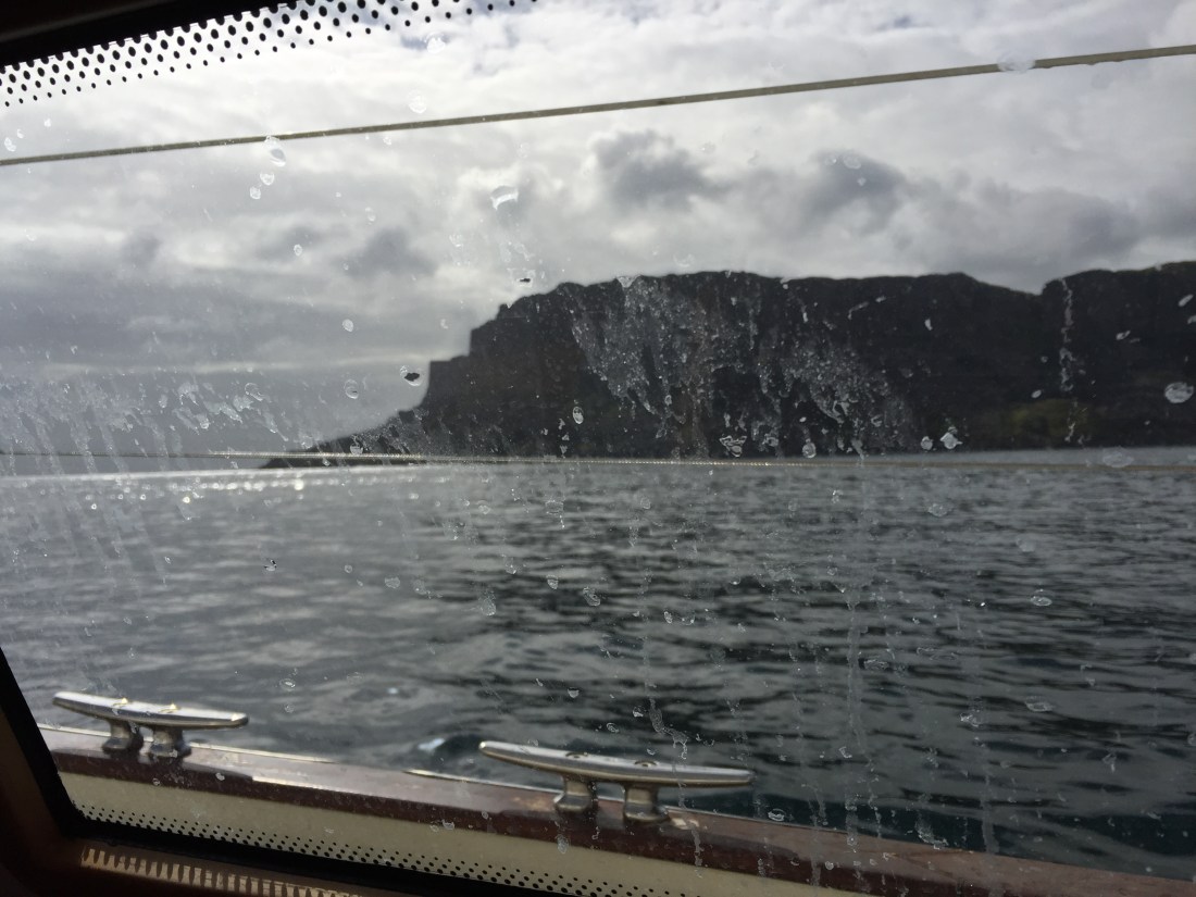
The great headland known as Fair Head was past at close quarters… huge black columns of granite towering above us. And at this point we joined the south going tide gushing in from the Atlantic… and our boat speed increased dramatically. Yesterdays record was quickly broken as we could see 13.6 knots on the “speedo” above the companion way hatch.

The twelve mile wide channel was crossed in under two hours…. the downtide swept us along and ever closer to Scotland. Here the North Channel is a major shipping lane… with two big lanes separated by a traffic separation zone in the middle… designated on all charts. As we were crossing at the southern end we did not have to go at right angles through the up lane, the TSL and the down lane. The huge peninsula of the Mull of Kintyre quickly loomed into view. Awesome dressed in greens, browns and black…with splashes of white at the base of the towering cliffs… where the great waves broke.
The sea conditions need some comment. Yes the rate of the tide moving west to east was quite staggering… but on the surface an oily, glassy calmness, no white horses, no huge crashing waves…. and no wind at all. All around peace and calm… the exact opposite to what was going on underneath the boat!
Once in the lee of the great peninsula, we navigated a passage through the stretch of water known as Sanda Sound. A small group of islands lay off the south eastern coast of the Mull of Kintyre… the Sanda Islands… and we chose to go through the gap between Kintyre and these islands. Wonderful views on both sides… we even spotted holidaymakers on the Kintyre side… in caravans and tents. With our Steiner binoculars!
After about three hours sailing ( motoring ) we spied the little island of Davaar… which marks the entrance to the Campbeltown Sound. This was rounded…. just as a northerly wind of 10 knots blew up… but too late for us as we had less than an hour to go. Once round the island we entered the excellent marked channel ( the green and red buoys pattern )…. and at 1.15pm we berthed in Campbeltown marina at the head of the Sound.
At least four guys came to help us with our lines… all such help is gratefully received and is part of the welcome that you receive at many marinas… but not all!!! Well done Campbeltown Marina. We had arrived in Scotland after 52 days and nights.
Distance sailed today… 36.2 n. miles.
Duration… 3 hours and 55 minutes.
Distance from Eastbourne: 1,308.9 n. miles.

Into whiskey land, well done.
LikeLike
Antrim at last Mr. T, it wasn’t so long ago that I yomped from Ballycastle along the cliffs to Lorna’s in Bushmills, awesome views and epic cliffs! It finishes with a traverse of the Giant Steps before crossing the black peat outfall river below the Bushmills whiskey distillery! You must get ashore in Islay where I once lived off the land and the wild beaches. We ate well.
Watch out for the Midges
Safe onward journey Poli Poli
Night watchman
LikeLike