
We departed our Liverpool Marina berth at 10.40am … a somewhat greyish, gloomy morning and very different to yesterdays scorching weather. Chilly too. But no wind, absolutely zilch.
We filled up with red diesel from the fuel berth first and then departed Liverpool Marina out through the lock at just before high water… so slack tide. Today we were going to take advantage of the tide and as it turned, and we went north out of the River Mersey, we would benefit from the ebb…. pushing us along from behind.
As you exit a channel, this time you “keep to the reds”…. this was repeated when we reported in on the Liverpool VTS VHF channel… the guy on duty said… “please keep to the reds” and we did so for the next 15 n.miles.
As we approached the Albert Dock… and it’s red buoy… a voice came over the VHF radio …. “Snowdrop here, Snowdrop here, come in Roli Poli”…. fortunately I had remembered that “Snowdrop” was the name of the Mersey ferry from two previous trips on her. The voice had a very distinct Liverpudlian accent. Without being rude, I corrected Snowdrop’s interpretation of our boat’s name… and asked how I could help.
Snowdrop informed me that he was behind Poli Poli and was about to come across us as he was heading to Pier Head. I agreed to slow down and let him pass… which he did. Roli Poli…. the old joke… I mused…. then I thought… who would call a boat “Snowdrop” especially one covered in multi layers and multi colours of what looked like street graffiti??
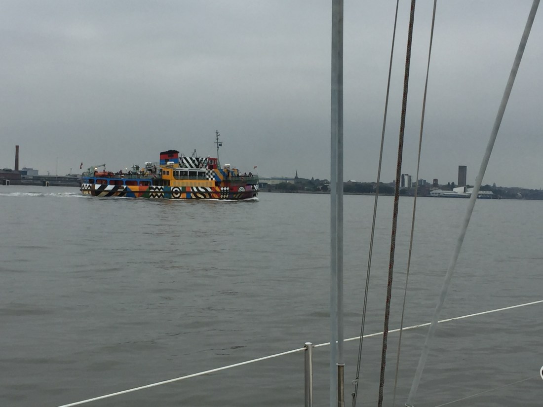
“Ferry across the Mersey”…. Gerry and the Pacemakers”…. here comes “Snowdrop” passing us at slack high tide.
The tide started ebbing and we certainly felt the benefit. Passing the Albert Dock, then the three famous buildings at Pier Head, we noticed a cruise liner moored up at the Liverpool Cruise Terminal. T noticed the company livery on the funnel and having seen the single word “Black” ……. something or other, decided it was the Fred Olsen ship “Black Watch”. Pat on the back…. correct.
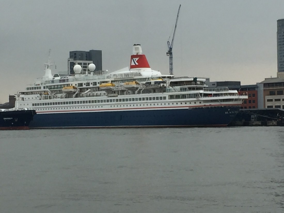
In the photo you can not only see “Black Watch” but the bow of an approaching vessel close to the cruise ship. This turned out to be the fuel tanker…. about to discharge fuel oil to the Fred Olsen ship… a process called “bunkering.”
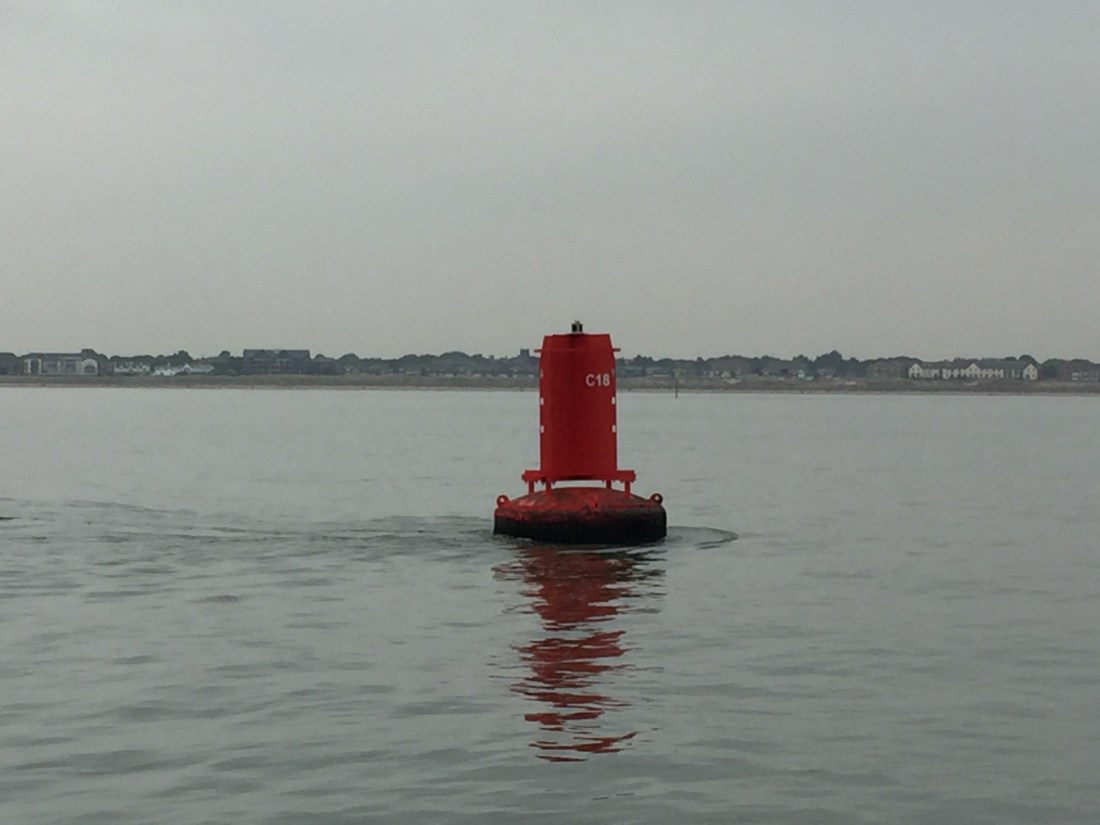
Here is a red channel marker buoy, C18…. and you can see the tide tail to the left. These “tails” tell you not only the direction of the tidal stream but also the strength and speed of the tide. It is when the buoy starts to tilt…. as when you have a Spring tide…. then you know immediately it is a strong tide.
With the help of the ebb tide we reached the Q1 buoy after two hours…. that is 15 n.miles from the marina lock. Good going. We then departed the shipping channel and informed Liverpool VTS over the radio. The Duty Officer wished us “a safe onward journey” and “good day”. Am impressed with Liverpool VTS service… very reassuring.
Our route now turned north west in a very long tack to the Isle of Man and it’s capital, Douglas. Once again we had to arrive no earlier than a certain time…. in this case it was 9.43 pm…when there was enough water in the inward channel and that a swing bridge would have to be opened for us.
This section of the route was motored all the way… the sea surface was flat calm with an oily, glassy sheen. Poli Poli was on auto pilot nearly all the way…. some 60 n.miles… with minor variations. We passed by a major gas and oil field and had to navigate safely to the east of it. Again this continued the theme of the Liverpool Bay “congestion” feature. Once passed this field we then had to negotiate the “South Morecambe oil and gas field” with supply ships buzzing about between oil and gas platforms. Some had gas flames burning off excess pressure showing as bright lights in the gloom
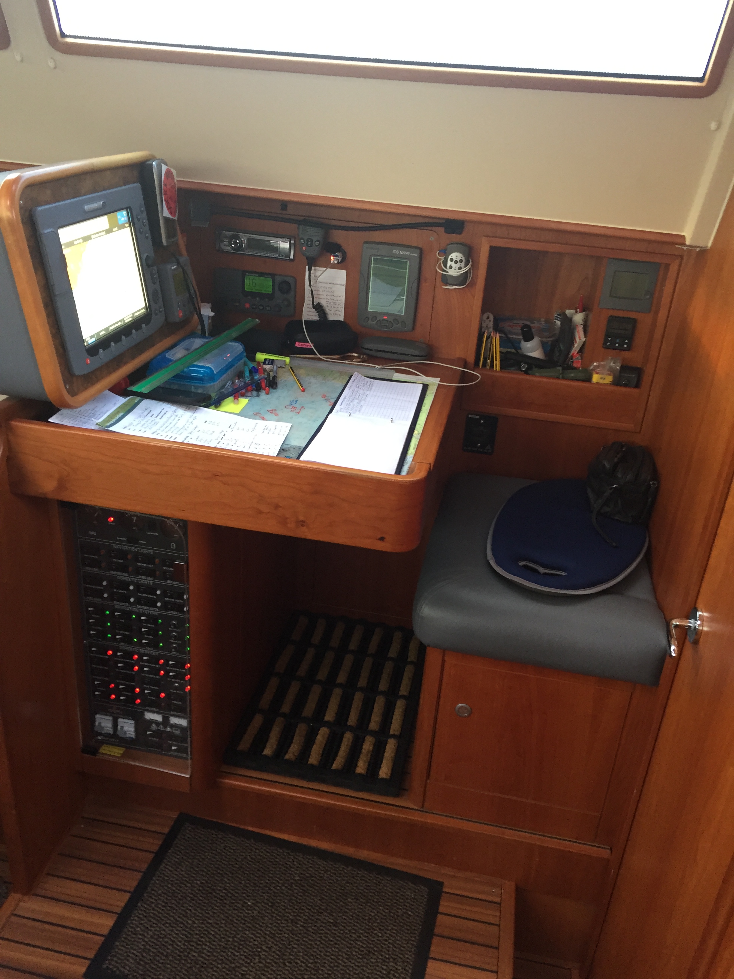
This is the chart table where all the navigation and “sums” are done before and during sailing. On the table is a paper “hard copy” chart with our route and hourly positions marked on it. You can see the “log book” open… recording our position every hour and to the left of the log book, is the overall “passage plan”. On the screen is an electronic chart showing our actual position, our heading and course line.
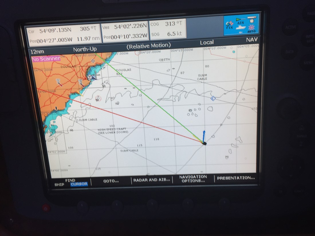
Here you can see that we are approaching the harbour of Douglas, on the Isle of Man. The green line is our intended course, whilst the red line is our actual heading. They are apart as a strong tide is pushing the boat northwards ( the blue arrow ). But as we near our destination the two lines will close as the green line is taking into account the effect of the tide. The yellow arrow is the wind. In this case dead ahead.
At about 65 n.miles, we realised that we were going to arrive too early… so from an average speed of just over 7 knots an hour, we pulled the throttle back to five. We finally arrived off the Douglas breakwater at 9.10pm.
We started our VHF Radio communication routine with the Douglas Port Control… informing them of our arrival etc etc. On this occasion we were informed that we must not enter the port as the very fast 30 knots Seacat Isle of Man-Liverpool ferry was about to arrive. We had been for warned that this might be the case… but could see no AIS signal on our screens nor actual visual contact on the horizon.
Then out of the far distant haze…. this “thing” appeared. We did circles well away from its intended track into the harbour. The Seacat is a huge vessel and has to do a 360 degree turn to face outwards before unloading…. so no small craft are allowed anywhere near it!
It is now nearly dark. So “circles” continued for 30 minutes before we were invited on the radio to enter the harbour. We had missed our bridge opening time of 9.45pm…and had to hold station in the approach channel for the next bridge lift at 10.15pm. We moored up at 10.45pm in the dark but still made the pub by 10.50pm for a pint. A long, long day. Rest Day tomorrow, Friday 13th July.

Poli Poli moored in Douglas Marina, Isle of Man… the next day, 13th July,
Total distance for the day: 75.3 n.miles. The longest single day sail to date.
Duration: 10 hours and 30 minutes.
Distance from Eastbourne: 1,152 n. miles.
